
 Research and Analysis
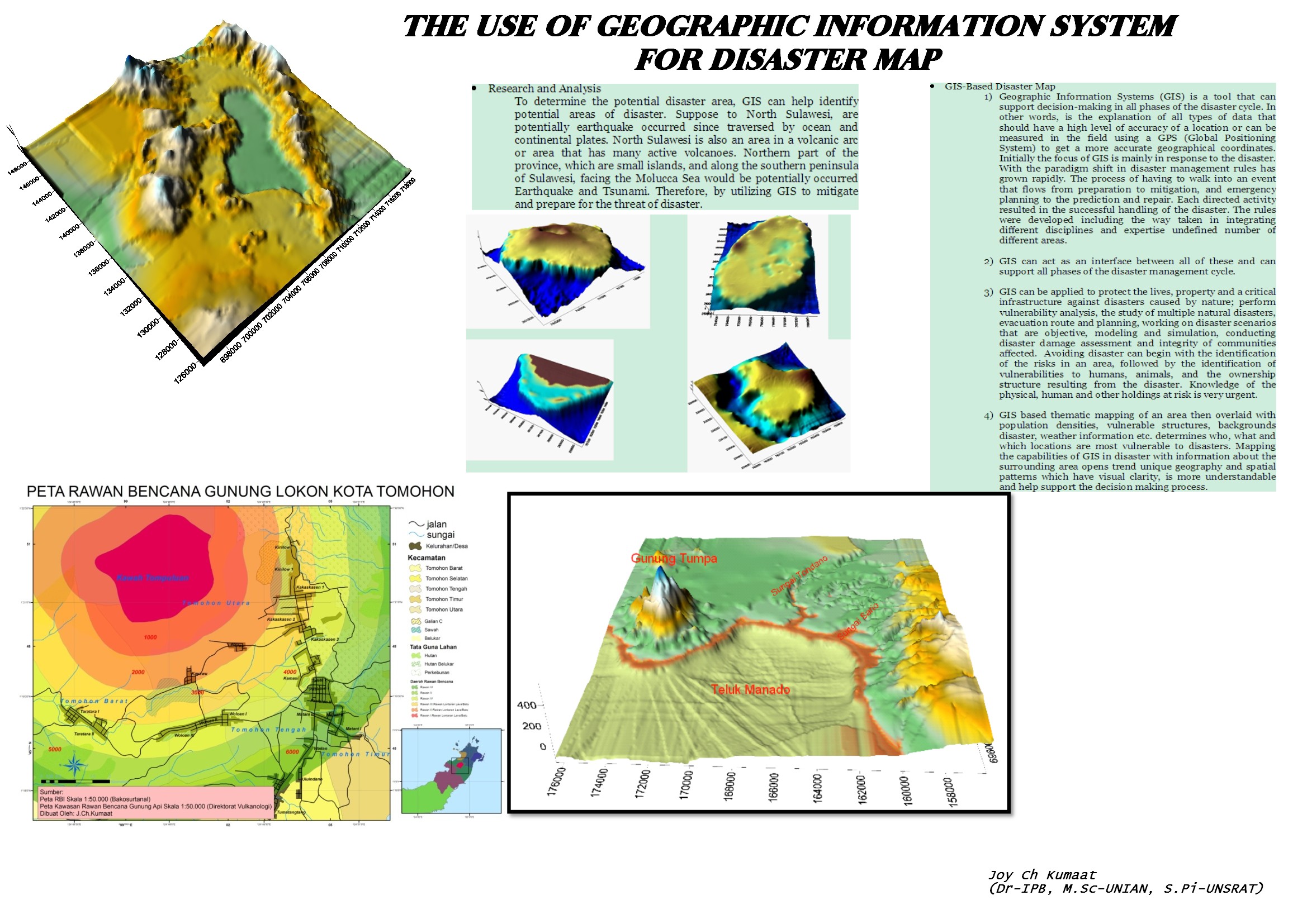
To determine the potential disaster area, GIS can help identify potential areas of disaster. Suppose to North Sulawesi, are potentially earthquake occurred since traversed by ocean and continental plates. North Sulawesi is also an area in a volcanic arc or area that has many active volcanoes. Northern part of the province, which are small islands, and along the southern peninsula of Sulawesi, facing the Molucca Sea would be potentially occurred Earthquake and Tsunami. Therefore, by utilizing GIS to mitigate and prepare for the threat of disaster.
GIS-Based Disaster Map
- Geographic Information Systems (GIS) is a tool that can support decision-making in all phases of the disaster cycle. In other words, is the explanation of all types of data that should have a high level of accuracy of a location or can be measured in the field using a GPS (Global Positioning System) to get a more accurate geographical coordinates. Initially the focus of GIS is mainly in response to the disaster. With the paradigm shift in disaster management rules has grown rapidly. The process of having to walk into an event that flows from preparation to mitigation, and emergency planning to the prediction and repair. Each directed activity resulted in the successful handling of the disaster. The rules were developed including the way taken in integrating different disciplines and expertise undefined number of different areas.
- GIS can act as an interface between all of these and can support all phases of the disaster management cycle.
- GIS can be applied to protect the lives, property and a critical infrastructure against disasters caused by nature; perform vulnerability analysis, the study of multiple natural disasters, evacuation route and planning, working on disaster scenarios that are objective, modeling and simulation, conducting disaster damage assessment and integrity of communities affected. Avoiding disaster can begin with the identification of the risks in an area, followed by the identification of vulnerabilities to humans, animals, and the ownership structure resulting from the disaster. Knowledge of the physical, human and other holdings at risk is very urgent.
- GIS based thematic mapping of an area then overlaid with population densities, vulnerable structures, backgrounds disaster, weather information etc. determines who, what and which locations are most vulnerable to disasters. Mapping the capabilities of GIS in disaster with information about the surrounding area opens trend unique geography and spatial patterns which have visual clarity, is more understandable and help support the decision making process.
- The use of GIS in disaster risk management range of database creation, inventory, GIS overlay the simplest to advanced, risk analysis, cost-benefit analysis, geologic processes, spatial statistics, decision matrix, sensitivity analysis, geologic processes, correlation, autocorrelation, and many tools and algorithms for spatial decision making more complex. Once again be recognized that in areas where the risk of the potential hazards, mitigation process can begin.
- GIS can be used in the determination of the priority areas for disaster relief following the application of appropriate building standards, to identify structures for retrofitting, to determine the safety assurance to the public and civil buildings, to identify the sources of, and training and capabilities specific to hazards encountered and to identify the flooded areas and the relocation of the victim to safety. The areas most vulnerable to disasters are a top priority in conducting mitigation. All of the measures taken aimed at avoiding disaster when implemented; the next step is to get ready to face the situation when disaster strikes.
- GIS has provided an ideal idea about everything expected.
- GIS for disaster preparedness is effective as a means for determining the location as a place of refuge outside the disaster zone, identify alternative evacuation routes based on different disaster scenarios, the best route to a hospital outside the disaster zone, specialty and hospital capacity and others.
- GIS can provide an estimate of the amount of food, water, medicine and others such as for storage of goods or logistics
